Master in Sustainable Urban Design 13-16 May 2024
School of Architecture at Lund University invites you to presentation days for Degree Project | Master in Sustainable Urban Design.
The presentations are public and take place in Full Scale Lab, A-building, Sölvegatan 24, 223 62 Lund.
Schedule for each day with name and title of the degree project (PDF, 461 kB).
Assar Ekander Swanberg
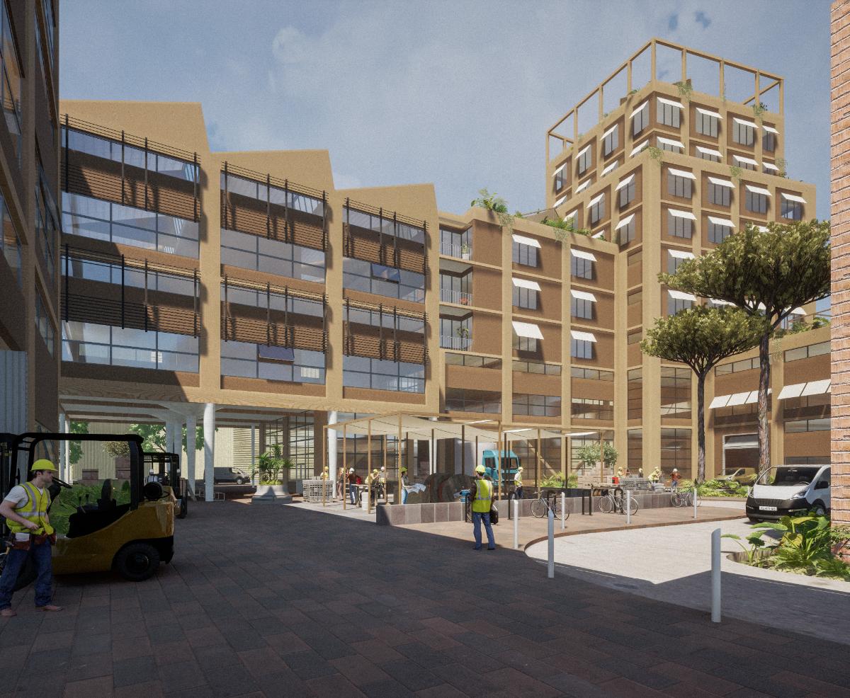
Transforming our economy from linear to circular requires new types of businesses in the manufacturing sector, material flows change from global to local. Our cities need to make room for manufacturing again, to repair, upcycle, design, make, resell, and produce local solutions. This presents an urban design challenge, how does a manufacturing area fit in to the climate adapted city needed to reduce our emissions and handle a changing climate?
Torrent d’Estadella, a small scale and diverse industrial area on the edge of central Barcelona is seeing transformation around it. A new train station, linear park and design university will soon be Estadella’s neighbors, changing its position within the city dramatically. It has potential to be transformed into a showcase of climate adapted urban design that facilitates urban manufacturing, a crucial tool to realize circular production. Intensified industrial space, shared yards, green streets, cultural spaces and more presents a new vision of what a manufacturing area can be.
The proposed design makes room for new manufacturing space alongside complementary uses that promote the creation of a circular economy and activate the area during more hours of the day. Repair centers, recycling facilities, material banks and design centers can work together in close proximity to make Estadella a hub for the sustainable economy of making in Barcelona. New connections and a logistical network improve the connectivity to Estadella making it an integrated part of the city, both for everyday workers and residents and the local supply chains that facilitate Barcelona’s shift towards a circular economy. Green streets and small parks provide everyday greenery and shading, an inviting environment that promotes soft mobility, cools down the city and creates spaces for everyday breaks. Estadella will welcome people to manufacture a sustainable future for Barcelona.

Erik Henckel / Gurkburk Development - Urban agriculture in brownfield development
The world's cities depend on a global food system where food is transported long distances between producer and consumer. That is not sustainable. A more sustainable system would be one where the food is produced in the city. Through urban farming, food can be produced in the city.
Harbour development projects are often ambitious projects where you want to develop the area with functions that benefit the public good. You often need to develop the area with high density so that you create many homes, workplaces and activities. However, this density can make it difficult to bring in urban agriculture in the development. Especially if you want to bring in a type of urban agriculture that contributes more than just food production, also recreational and ecological values.
The aim of the thesis is to investigate how to design a harbour development with urban agriculture and at the same time have high density. The purpose is also to test how both hobby recreational cultivation and professional commercial urban farming can be designed within this development.
The investigation is a case study of Norra Västerport in Varberg, Sweden. A proposal is produced which then constitutes an example of how the area can be designed to achieve the municipality's goals with the site and also to enable urban agriculture within the development.

Binyou Wang / A livable, historic district with memories
Shantou Small Park historic district Urban Renewal, China
Cities with strong historical and cultural identity are always desirable. However, due to their long history, some cities have not fully considered the sustainability of urban development in the past design, and it is difficult for cities to meet the needs of current site residents after a long period of social development.
As a result, people have a strong sense of belonging to the site due to the historic quality of the site. The quality of living is not as good as in recent modern planning and design of new communities.
The research and project proposal of this thesis is located in the small park Historical district of Shantou City, Guangdong Province, China. The site is located in the coastal area of southeast China with a subtropical climate and is a port city.
The site has a large proportion of historic protection buildings, few buildings that can be demolished, poor building quality and high building density, no reserved public space and greening in the block, clear road framework and good transportation accessibility. The living environment of the site needs to be improved.
In view of this problem, I have analyzed the current situation and concluded that three aspects need to be improved. The first is to improve the building quality and restore and update historical buildings under the condition of building sustainability. The second is the need to increase the landscape greening, by increasing the roof greening and increasing the public space greening two ways to create landscape space; The third is the need to create public space, using the main nodes created after the demolition of the building, while looking for limited space in the current situation to create interesting public space.
To create "A livable, historic district with memories."
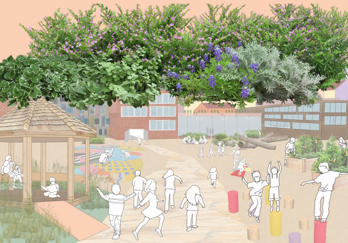
Stella Boycheva / A Child’s Garden City: An exploration of child-friendly design in modern day urban spaces with a focus on Prague
Children do not have many spaces designed entirely for their needs in our modern world. This has inspired the concept of ‘A Child’s Garden City’. The idea includes research of how children can be included in design and the process of creating safer cities with their considerations in the center.
This Master’s Thesis can inspire the relationship between growing natural vegetation, self-sustaining infrastructure and community all considered from the perspective of different age groups of children that will have their childhood within this environment.
Urban Green Infrastructure (UGI) is a large part of ‘A Child’s Garden City’. UGI includes different natural sustainability features to help with greener communities. Factors such as forests, wetlands, urban agriculture, community gardens, urban trees, green roofs, rain gardens, swales and ecology on a micro-scale can help a community become more sustainable in water management, food creation and economical status. This is very significant for a future where the resources on our planet are limited and we need to find ways to work together and combat negative environmental implications. Introducing children to these factors of sustainability early on in their lives can help the future significantly. Through time, green developments will grow into larger, more used communities by children today and other future generations.
Child-oriented communities should also include aspects of nature and play. Urban spaces should be created with play and nature integrated within and throughout. Cities with a children-oriented perspective to the world can encourage education, use and adaptability in different forms. It is fascinating to see how children can learn through their environment and how much more they would care about the environment and sustainability if it was implemented around them from a young age and taught to them within a growing space. Child-friendly urban design is therefore valuable for humanity’s future in sustainability and development.
Camille Lambreth / Reshaping the Ribbon: Enhancing the community of a Ribbon Development in Flanders through a green corridor and densification
While the world’s population keeps growing and our cities keep getting more and more dense, urban sprawl is a phenomenon that affects a big part of our society. Research has shown that urban sprawl lacks consideration for human interactions and has an absence of proper urban planning.
Multiple types of barriers have made it more and more difficult to create a sense of community within this environment. Due to the lack of densification, urban sprawl also directly impacts air pollution and therefore is a big contributor to climate change. However, is there a perfect solution to address this 21st century phenomenon? Is proper urban design the answer?
This master’s thesis will be analyzing the urban development of the Belgian, more specifically, the Flanders region. As a result of certain regulations and norms Belgium has become one of Europe’s most sprawled countries. It is the notion of ‘Ribbon Development’, an urban sprawl pattern specific to Flanders that will be redesigned.
Through past research and case studies, a toolbox that focuses on three regional strategies created the base of this project. Each individual local design tool enhances these strategies. The Green, The Social and The Infrastructure are the focal points on how to improve the community lifestyle of towns that are placed in Ribbon Development condition.
Through a green corridor belt and the future’s predicted densification, this project aims to create a model for the rest of Flanders and guidelines for the rest of Europe on how to deal with the future of urban sprawl. A ‘one-size-fits-all’ solution is not the answer, but human scale interactions are necessary to help enhance the community’s lifestyle within this present-day dilemma.
Joanna Kopacz-Gruzlewska / ‘Modular City’ For Internally Displaced Persons
Refugee modular housing and placemaking: finding synergies between the short-term and long-term dynamics of sustainable urban development.
Zaporizhzhzia, Ukraine
The modular system in the construction industry offers a solution to the growing demand for rapid accommodation in areas suffering from a lack of decent housing. Such areas are particularly those affected by natural or man-made disasters.
Those recurring disasters are resulting in an increasing number of displaced people who need to be provided with urgent accommodation. Due to insufficient legal regulations and effective construction methods, refugees are often located in conditions defined as ‘temporary’, offering low quality of living conditions, degrading social environment and destructive impact on the city landscape. However the duration of their accommodation often proves to be much longer than assumed initially.
On the other hand, attracting people’s attendance is one of the main objectives of the urban strategies aiming at converting abandoned or degraded places into liveable and vibrant city spots. In the process of managing a massive group of displaced persons, the presence of people can be regarded as an immense resource in refurbishment of obsolete parts of the city by incorporating their participation in the process of redevelopment of the built environment.
One of the most important components of the placemaking process is participation in the decisions of future residents or users. Strategies for involving citizens in decision-making also serve to assess the potential of a place and, as such, can become an important determinant of investment direction.
In this thesis, I examine the potential for IDP housing to serve as a catalyst for long-term placemaking. I use the district of Dniprovskiy in Zaporizhzhia, Ukraine as a case study to illustrate how the strategy of modular housing implementation can be integrated with citizen participation and placemaking principles to create a liveable built environment that benefits displaced people as well as long-term residents. The findings identify multiple synergies: the rapid implementation of modular housing and the long-term development of vibrant and sustainable neighbourhoods.
Erik Ivanoff
Studies show that urban highways play a vital role in facilitating transportation within metropolitan areas, yet they often come with significant drawbacks, including physical barriers, urban decay, and environmental degradation. In Sweden, where the transport sector is a major contributor to greenhouse gas emissions, the city of Gothenburg stands as a prime example of these challenges.
Located along the river Göta Älv, Gothenburg boasts a rich industrial history that has shaped its identity and economic landscape. However, the decline of traditional industries has left behind outdated infrastructure and a car-centric urban design paradigm that hinders sustainable development. Moreover, the city's proximity to the river makes it particularly vulnerable to the impacts of climate change, such as rising sea levels and extreme weather events.
To address these pressing issues, this master's thesis focuses on the transformation of the Southern Riverbank—a critical but underutilized coastal strip—into a vibrant and integrated part of Gothenburg's urban fabric. By adopting principles of regenerative development and innovative urban design strategies, the aim is to reimagine this area as a sustainable and reconnected resilient space that enhances the well-being of the city's residents while mitigating the effects of climate change.
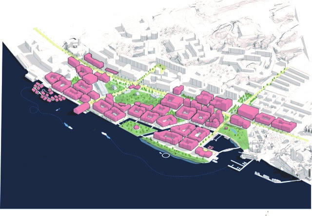
Hanna Lundell / Facing climate reality for waterfront areas - An adaptation and implementation of public use at Seafield beach in Edinburgh, Scotland
We are living in an era where the impacts of climate change are becoming increasingly evident, and scientists worldwide are expressing alarming future predictions for extreme weather events.
Coastal areas, in particular, are globally threatened by rising sea levels, a consequence of factors such as thermal expansion, melting ice, and coastal erosion. Urban planning and design are closely intertwined with these challenges and should therefore prioritize spreading awareness and addressing them to ensure the safety of both human life and ecosystems when planning new neighborhoods.
Edinburgh, situated in Scotland, is just one of many cities worldwide located along the coast, with the entire city facing towards the sea. Despite the numerous challenges faced by coastal areas, it is crucial not to overlook their ecological and social significance. Coastal regions serve as vital habitats for biological diversity and are essential biotopes in their own right. Additionally, they hold immense recreational value, providing people with spaces to visit and enjoy leisure time. Seafield beach, a coastal area along Edinburgh's coastline, has unfortunately been neglected over the decades, caused by a decline in green diversity and increased pressure on ecosystems.
In this project, my aim is to design an area close to the coast while considering the potential impact of rising water levels. I propose a flexible design approach that can adapt to changing weather patterns, ensuring that residents are aware of climate change and prepared to respond accordingly. A place where flexibility and movable objects can be used as a tool for creating a desired character and atmosphere. Simultaneously, I seek to reclaim this beautiful location for the public of Edinburgh by enhancing the beach promenade and creating several key public spaces, transforming Seafield into an active and vibrant part of the city.

Muram Abdelrahman / The Taya dike, design beyond protection - A Resilient urban approach to mitigate the risks of riverine floods
The Nile, a significant river flowing northward for 4,132 miles and spanning eleven countries in northeastern Africa, holds immense importance. One focal point is Tuti Island in Sudan, where the convergence of the White Nile and the Blue Nile forms the mighty Nile River, serving as both a blessing and a challenge for the local community.
These rivers bless Tutians with fertile soil, turning the island into an agricultural hub. However, the annual river floods during the four-month rainy season bring substantial challenges, hindering urban growth and threatening lives, causing extensive harm across various aspects of life.
The community of Tuti, internationally recognized for their unity, independence, and resilience in facing flooding, earned acknowledgment from the UNDRR in 2015 as a Champion of Disaster Risk Reduction. Their mastery of traditional flood management systems, notably the Taya system, highlights their skill in coping with risk through indigenous knowledge.
This thesis advocates drawing inspiration from age-old local practices and utilizing the inherent wisdom of indigenous communities to create permanent solutions tailored to the environment. This includes involving locals, who have long played a crucial role in voluntary efforts to protect their homeland.
Furthermore, the thesis proposes an urban development plan for the island as a second phase of safeguarding it from flooding, aiming to support sustainable urban expansion and long-term residential appeal while enhancing its central strategic location in the middle of the three towns in Khartoum state.
By blending traditional wisdom with modern approaches, the goal is not only to mitigate the challenges posed by flooding but also to enrich the region's heritage and enhance its attractiveness as a new landmark.
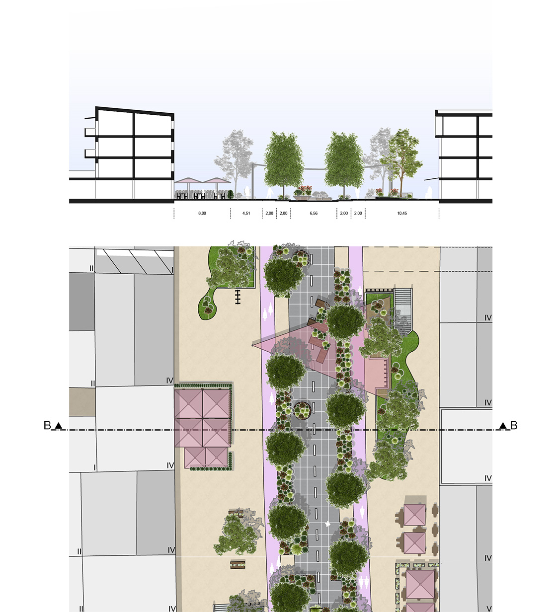
Kathrin Buschhardt / Stay a While: Redesigning the built city center of Burghausen to prioritize the people
The motivation for this project is the current focus on cars in the city centers in smaller towns. More rural areas are more dependable on cars as a means of transportation. Therefore, the space for the pedestrians needs to be added or added. This leads to citizens of the towns wanting to save time in the center. The centers become unlively and unatractive.
Burghausen is a small town on the country site in Germany. The city itself promotes the usage of cars over biking and walking. The reasons for that are the sudden ending of bike paths and streets with no sidewalks. Also, looking at the Center of the Town supports that image, including wide streets, street parking, underground parking, and high-traffic streets.
Currently, there are beter places to spend time than the city center. People use it to get shopping done and then go home again. Looking at the sidewalks serves the purpose of geting from A to B more than inviting pedestrians to stay and interact with each other. The reasons are fewer benches, a lack of quality squares, the safety of geting around on foot or biking, and noise pollution from the traffic.
This project aims to transform the city center into a welcoming space encouraging people to stay and enjoy their time. We propose the development of a pedestrian street and a seasonal street, with roads being closed permanently or during the summer months. Parking spaces will be repurposed into sidewalks and squares. A comprehensive Toolbox will be implemented, including urban furniture, greenery, pocket parks, activities, road blockage, safe street crossing, and water management. These changes hold the promise of a more vibrant and atractive city center
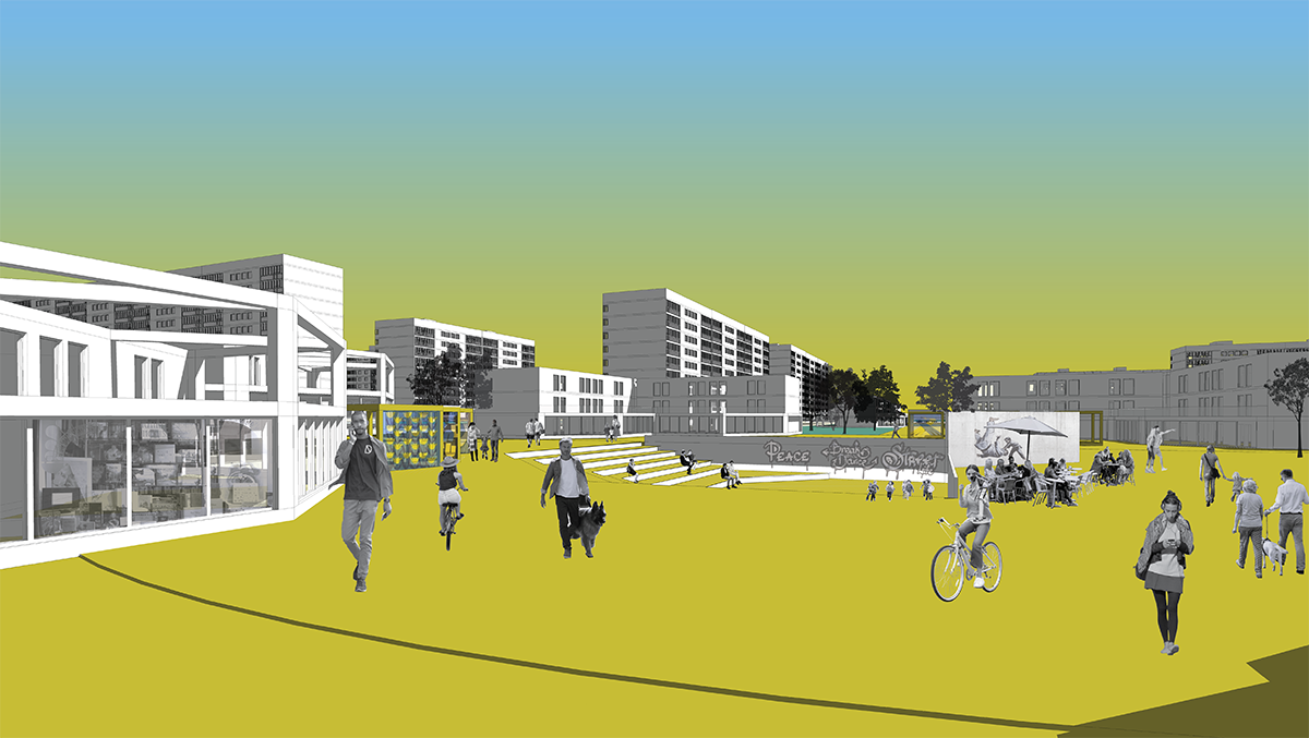
Lovisa Öquist / Green-blue pathways – Enhancing city connectivity and urban vitality through green-blue infrastructure
Our world is facing major challenges and the built environment plays a major role in both adapting to, and, challenging the current situation. As urbanization advances and densification takes place, more people reside in cities with an estimated 68% of the world's population expected to live in urban areas by 2050.
Urban areas confront mounting challenges due to population growth, resource constraints and the escalating effects of climate change. Tackling these issues is crucial to ensure cities offer healthy and sustainable living conditions.
What research clearly indicates is that urban green and blue spaces have the potential to play a vital role in achieving the Sustainable Development goals of the United Nation. With connection to both urbanization and densification, as well as people’s health – not to mention climate change – the importance of nature and greenery can not be emphasized enough as its function and presence is important both on an individual level and for entire societies. Urban green and blue spaces not only provide benefits for the environment but also improve public health and well-being. The aim of this thesis is to investigate how the spatial organization of a densification development in Norrköping, Sweden, can be arranged with focus on green-blue values as a driver for transformation, activation and integration and create a lively, mixed used and pedestrian friendly district that also improves the overall connectivity in a city scale. The design proposal attempts to meet the needs of a growing city where the holistic benefits of green-blue values play the key role
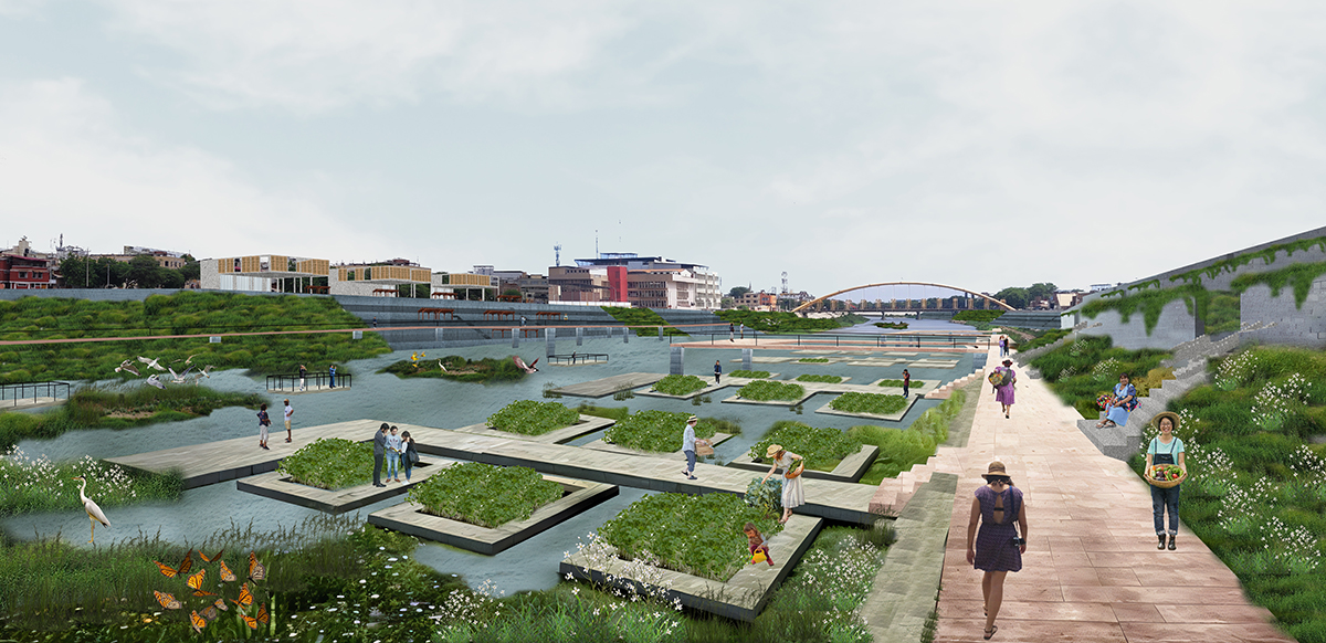
Ruth Zaragoza Chinchayan Barreto / Reactivate The River Piura, To Reconnect The City With It’s History
As a Latin American country, Peru faces numerous challenges due to the fast urban development without adequate urban planning. Consequently, many Peruvian cities grapple with the repercussions of natural disasters.
One of those is Piura characterized by its hydrology because of the quantity of basins it has, and the fast increase of population over the last 60 years.
Because of its hydrology and location on the coast, this province is one of the most affected by “El Niño” southern oscillation, which is a superficial change of temperature in the water.
This situation occurs every 3 to 6 years which increase the temperature to around 10 °C, humidity, rainfall, river overflow, and reduction of agriculture and fishes on the ocean.
But 3 districts of this province have a particular situation, because of the pass of the main riverbed, which divided the urban fabric almost in two.
So, throughout history, that river has been part of the city since the first settlement and was considered a natural public space (small beach but also to graze animals).
Nowadays, it is used to trash rubbish and not included in any urban plans because is seen as a potential enemy related to the river overflow that has been flooding the city and destroying buildings and roads over the last 70 years.
For that reason, the vision of my project is to reactivate the river to reconnect the city with the history in which the river is the public heart of the urban life with new green areas, that will help to reduce the deficit of public areas through the design of a new corridor along the river, activated with new activities related with the existing ones around.
To then be able to say: WELCOME TO THE RIVER AGAIN!
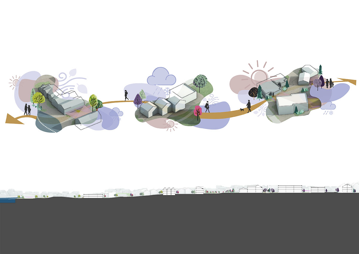
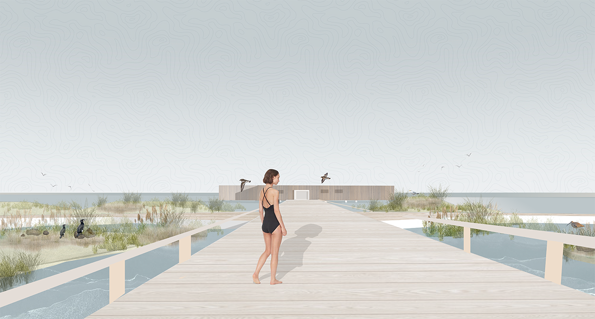
Sophia Spock / Climate Response: A study in microclimate design and its impact on seasonal life in Åkrehamn, Norwa
Climate response studies the microclimate conditions of the site and explores how to design with and around those conditions to create more pleasant and lasting public spaces. As Åkrehamn grows into a local center, these spaces will provide a framework and center for its future development.
Currently, Åkrehamn has a poorly defined town center, which limits the spaces people have to gather in. Thus, the design focuses on creating public spaces for residents to use throughout the year. It also has a strong climate, which currently limits the use of outdoor spaces. Additionally, Åkrehamn struggles with walkability because much of its development has been designed for driving, not walking. This limits the feeling of connection between the town center and the sea because many roads lack clear sidewalks, and there are not many people-focused or accessible places, especially along the harbor. Because of this, creating public spaces for the residents and designing connections between them is a priority in the design.
To achieve this, the project establishes a deployable toolbox of climate strategies and intervention methods that will be placed on the site strategically based on climate analysis findings. The interventions will have various performance scales, including large-scale building placements and smaller seasonal methods. Doing so allows for multiple levels of seasonal interactions as people move within and use the space throughout the year. By focusing on year-round adaptability, Climate Response explores how the town might further engage with its microclimate as it develops to create public spaces that remain pleasant and lasting over time.
In doing so, it aims to answer the following questions:
- How can microclimate analysis help identify vulnerable areas in local centers?
- How can climate-responsive design strengthen local centers and their connections?
- How can we apply climate strategies to create pleasant and lasting public spaces that respond to seasonal climate and movement
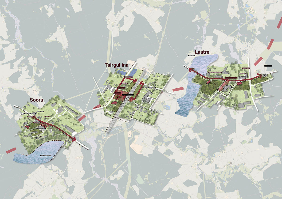
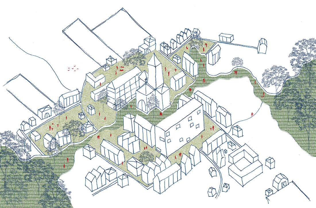
Luize Eglite / Rural settlements: how to work sustainably together – The case of Tsirguliina village in Estonia
With urbanization people are traveling and settling closer and closer to bigger cities, where all the economical, social and work opportunities are the most. But where are these people coming from?
Rural areas in Europe cover around 80% of the land area together, but only 30% of EU’s population lives in rural areas. Mainly people settling in cities are from smaller settlements leaving their original homes empty and in a slowly degrading phase as fewer people live there, shops and schools close, there are less investments and less interest in people to call it a home. Rural settlement idea is to work together and provide the balance of people coverage. Creating sufficient network systems between small settlements can keep the existing functions running, strengthen communities and work towards future goals together.
As Baltic states are one of the countries ranking with the biggest decrease in population overall, small 15 settlements were analysed and compared in 1 municipality of each country. Comparison of spatial qualities and arrangements of the villages themselves concluded into a rating, that showed the most popular elements and functions as well as weaknesses between the villages, municipalities and Baltic State villages together.
Outdoor design, smart village tools and different scale connections were used to create a pilot project in Estonia’s municipality of Valga around Tsirgullina village. For achieving the goals 3 main target groups were defined, prioritizing existing residents the most, then concentrating on visitors and then on new residents in the future. After rebranding, providing daily features and sustainable solutions it shows how settlements can work sustainably together with 2 other similar scale villages.